Strong storms moved across North Texas earlier today. Light to moderate rain will continue falling through the morning.
Update, 10:37 a.m.: The Associated Press offers this weather roundup: "About 16,000 homes and businesses have lost power during North Texas storms. The weekend storm system that dumped more than 7 inches of rain in Granbury lingered in Dallas and Fort Worth on Monday. Electric utility Oncor reported more than 8,000 outages in North Texas. Other outages ranged north to Wichita Falls and south to Waco, which received more than 4 inches of rain on Sunday. The Hood County Sheriff's Office had no immediate reports of anyone hurt during storms Sunday in Granbury, 30 miles southwest of Fort Worth. Some roads and the Brazos River flooded. The National Weather Service reports the Granbury area on Sunday received 7.36 inches of rain. Granbury previously had about 7 inches of rain all year."
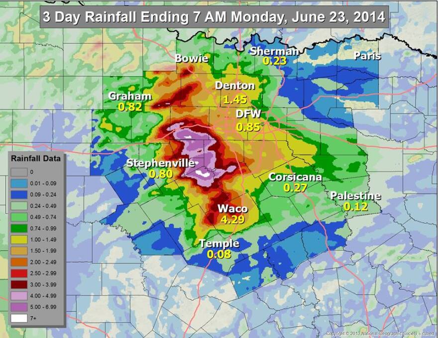
Update, 9:40 a.m. The National Weather Service has released a map showing three-day rainfall amounts through 7 a.m. Monday. Areas west and south of Dallas-Fort Worth have received the most rain.
Dallas-Fort Worth International Airport has recorded .85 inches of rain, while Denton has recorded 1.45 inches. Waco has gotten 4.29 inches. Hood, Somervell and Bosque counties are among the areas receiving the most rain over the past three days.
Lake Granbury has risen nearly 5 feet since Sunday, the weather service says.
On Sunday, an area south of Glen Rose received the most rain -- 8.5 inches. Glen Rose is in Somervell County.

Here's an updated radar image from the National Weather Service
Original post: A severe thunderstorm warning was in effect until 7:45 a.m. for several counties, including Dallas, Rockwall, eastern Collin, southeastern Tarrant, Johnson, southern Hood, northwestern Ellis and Somervell.
Meanwhile, an urban and small stream flood advisory is in effect until 9:45 a.m. for Denton and Tarrant counties.
Before 7 a.m., heavy rains were falling near Lake Lewisville, Grapevine, Arlington, North Richland Hills and downtown Fort Worth, the National Weather Service says.
Expect some roads to be covered with water. Motorists should slow down to avoid losing control, the weather service says.
Monday’s storms come after heavy rain hit parts of North Texas Sunday – more than 8 inches in some parts.
The Fort Worth Star-Telegram reports:
About 18 people had to leave their homes in the Sunchase Acres Addition in east Granbury, where the rainfall total was about 6 inches, Hood County Emergency Management Coordinator Ray Wilson said. He said other homes were reportedly flooded in the Quail Park Addition, also in east Granbury. … The National Weather Service issued flash flood warnings Sunday afternoon for several counties south and southwest of Fort Worth. The top rainfall total recorded Sunday was 8.5 inches south of Glen Rose, which is about 16 miles south of Granbury. In the Hood County area, rainfall totals were 3.5 inches in Hideaway Bay Estates, 3 inches in Acton and almost 3 inches in Pecan Plantation, according to the Hood County News website.
The Dallas Morning News reports:
Steady showers dropped a little more than half an inch of rain at Dallas/Fort Worth International Airport on Sunday, while areas to the south and southwest were drenched with up to 8 inches of rain, forcing evacuations and stranding motorists. … So far, this year is the sixth-driest on record. But before Sunday’s showers, it was the fourth-driest. … Soaking rains were also recorded in Tarrant County. Some Arlington neighborhoods got 2 inches. It could be a wet week, with a 30 to 40 percent chance of scattered showers through Wednesday. Scattered thunderstorms are possible Monday.


