


Update, Sunday night: The rain kept falling and falling -- and when it finally stopped, 21 inches fell in Corsicana in Navarro County, which is about an hour south of Dallas.
There was an unofficial report of 28.9 inches of rain in Dawson, a small town in Navarro County.
All that water made driving a mess. Interstate 45 between Dallas and Houston had to be shut down in Corsicana repeatedly throughout the weekend. There was also a levee breach west of I-45.
Emergency officials recommended that motorists stay off secondary roads. County officials performed dozens of high water rescues, getting calls from people stuck in cars, homes and businesses.
A Union Pacific freight train derailed near Corsicana early Saturday morning. Chambers Creek was overflowing and washed out the tracks. Two crewmembers were on board – they escaped by swimming to safety. Nobody was hurt.
The Corsicana school district is delaying school until 10 a.m. Monday. Several other school districts in Navarro County are closed Monday because the roads aren’t safe. They plan to reopen Tuesday.
Everyone in North Texas got some rain. Dallas-Fort Worth International Airport recorded more than 7 inches. Denton saw 5 inches, Sherman saw 4 inches and Paris recorded nearly 7 inches.
In Dallas-Fort Worth, the weekend rainfall means we’ve seen more than 46 inches of rain all year – it’s the seventh wettest year on record, the National Weather Service says.
Update, 11 a.m. Saturday: Some parts of North Texas received nearly 20 inches of rain on Friday, the National Weather Service says. The hardest-hit area was southeast of Dallas-Fort Worth – between Waco and Palestine, including Corsicana in Navarro County.
Corsicana, about 60 miles south of Dallas, received more than 18 inches of rain since Friday morning, the weather service says. The town of Powell, located just east of Corsicana, had more than 20 inches of rain.
A flash flood watch continues for all of North Texas through 7 a.m. Sunday. Dallas-Fort Worth could see 1 to 3 more inches of rain before things dry out. Areas south of Dallas-Fort Worth could see 3 to 6 additional inches.
Problems on Interstate 45
High water once again forced the closure of Interstate 45 in Corsicana, between Dallas and Houston, late Saturday morning.
I-45 had reopened in both directions earlier in the morning after heavy rain and flooding forced overnight closures in the Corsicana area.
TxDOT advised drivers to use caution because water remained on some parts of the busy highway. For the latest driving conditions around the state, check drivetexas.org.
SB detours, I-45 flooding:I-35E to SH 171, Hillsboro to Mexia, then EB US 84 to I-45 Fairfield. Local SB cars turnaround @ Ellis county line
— TxDOT Dallas (@TxDOTDallas) October 24, 2015
NB detours set soon for I-45: US 84 in Fairfield, west to SH 171 in Mexia, north to I-35E. Local traffic turnaround at FM 1394 in Richland.
— TxDOT Dallas (@TxDOTDallas) October 24, 2015
Train derails near Corsicana
A Union Pacific freight train derailed near Corsicana, where the tracks washed away. Two crewmembers who were on board escaped by swimming to safety.
Union Pacific spokesman Jeff DeGraff says the derailment happened around 3:30 a.m. Saturday in an area 4 miles north of Corsicana. DeGraff says Chambers Creek was overflowing and washed out the tracks.
He say one locomotive and several rail cars, hauling loose gravel, went into the water and were partly submerged.
DeGraff says both crewmembers on board "swam to high ground" and were rescued by emergency responders. Nobody was hurt.
DeGraff says the 64-car train was traveling from Midlothian to Houston.
Accidents in Dallas
The water has snarled traffic across Dallas-Fort Worth, causing scores of accidents. Dallas police say there were more than 480 accidents between midnight Thursday and Saturday morning. Of those, 147 were major freeway accidents. Dallas police also report more than 30 calls to help people stuck in high water between midnight Thursday and Saturday morning.
More rain on the way
Forecaster Jesse Moore says remnants of Tropical Storm Patricia, which made landfall Friday in Mexico as a hurricane, are expected to send more rain into parts of Central and South Texas through the weekend.
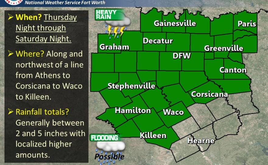
The National Weather Service says the heaviest rain will fall south and southeast of Dallas-Fort Worth, along a line from Killeen to Waco to Canton. Areas south of that line could get 2 to 4 additional inches of rain, the weather service says.
The flash flood threat has ended for areas north and west of Dallas-Fort Worth, alone a line from Cisco to Denton to Sherman, as well as towns west of that line.

Elsewhere in Texas
Emergency responders in San Antonio are trying to find a man who was swept away in a flooded drainage ditch while walking a dog.
The San Antonio Fire Department says the incident happened around 3 a.m. Saturday.
Authorities say the dog was walking close to the canal when the man, while trying to pull the pet back, fell into the water.
Firefighters were unable to locate the man, as a rainstorm soaked parts of San Antonio. The search was dropped after about two hours, due to weather, but authorities planned to resumed the search later.
The dog was safely retrieved.
BREAKING: vehicles getting stranded now in Corsicana, TX @breakingweather @TVNweather pic.twitter.com/PN7f1FLqZF
— Reed Timmer (@ReedTimmerAccu) October 23, 2015
National Weather Service radar
Friday weather updates
Update, 5 p.m. Friday: North Texas is soaked, with many cities getting up to 6 inches of rain since Thursday. Some areas have gotten much more. And we'll see even more rain through the weekend.
Expect 2 to 5 additional inches in areas north of Interstate 20 through 7 a.m. Sunday. Areas south of I-20 will get 4 to 8 inches.
The National Weather Service says areas that have seen heavy rainfall since Thursday will be more susceptible to rapid run-off and flash flooding.
Commerce has been hit hard by rain. The Hunt County town, northeast of Dallas, had recorded 10.13 inches of rain through 2:30 p.m., the National Weather Service says.
South of Dallas-Fort Worth, in Navarro County, Corsicana had recorded about 10 inches of rain through 4 p.m. A flash flood warning is in effect for Navarro County through 10 p.m.
As of 5:30 p.m., Interstate 45 in Corsicana was closed because of high water. Several city roads are also closed. There are reports of vehicles stranded in the water.
Update, 2:39 p.m.: Heavy rain continues to pound areas south and east of Dallas-Fort Worth -- from Killeen to Corsicana and up to Paris. But more storms are brewing to the west -- and they'll hit North Texas later today.
Expect those storms to arrive between 5 and 8 p.m. Heavy rain, lightning, flash flooding and gusty winds are all possible, the National Weather Service says.
South of Dallas-Fort Worth, in Navarro County, the Office of Emergency Management says that several roads have been flooded and there are many reports of stranded vehicles. County officials are encouraging residents to stay off the roads.
A flash flood watch remains in effect through 7 a.m. Sunday for North Texas.
Video: Watch street flooding in Fort Worth
https://www.youtube.com/watch?v=99GcADNmz7s
Update, 1:45 p.m.: The National Weather Service has updated some rainfall amounts across North Texas. Many areas have reported 2 to 4 inches of rain, although some areas have recorded 5 inches.
Dallas/Fort Worth International Airport has recorded 4.61 inches through 1:30 p.m. Friday. Dallas Love Field has gotten 3.53 inches. Denton has seen 3.29 inches. McKinney has reported 4.57 inches.
Waco has reported 4.08 inches. Corsicana has recorded 6.05 inches.
About 20,000 North Texas customers were without power as of 1 p.m.
Emergency management officials in Texas contending with multiple storm systems are preparing for heavy rains to continue through the weekend and widespread flooding that may follow.
Rain fell steadily Friday through much of the state and is forecast to continue through at least Saturday as a storm system slowly moves eastward.
Many parts of Texas, including Dallas and Houston, could see upward of 12 inches of rain by early Saturday.
Officials are concerned the current system will be followed by the wet remnants of powerful Hurricane Patricia, which is now approaching the west coast of Mexico.
The systems will bring the most rain the state has seen since the devastating Memorial Day weekend flooding that led to at least 30 deaths.
In Dallas, there were 16 street closures as of early Friday afternoon. Click on this link to see the locations.
About an hour ago, straight line winds crashed this tree in the park near City Hall. Parks crews are on scene. pic.twitter.com/M6ZQK8kwse
— Farmers Branch TX (@FBTX) October 23, 2015
Video: The scene in Powell in Navarro County
Flooding issues in Powell, TX. #dfwwx #TADD pic.twitter.com/ccSpZI9E8h — Navarro County OEM (@NavarroOEM) October 23, 2015
Update, 12:06 p.m.: The Trinity River in Dallas is past flood stage. The National Weather Service reported the banks were at 31.11 feet at 11 a.m.
The following highways and roads have been affected by high water:
- State Highway 183: All eastbound lanes are closed east of Loop 12 in Irving.
- Loop 12: Flooding has been reported over Loop 12 near Walton Walker in southern Dallas, affecting both directions of traffic.
- Spur 348: The entrance ramp from 348 to eastbound Highway 114 is closed due to flooding.
- Highway 26 at Brown Trail in Colleyville is flooded.
- East 820 at Rosedale in Fort Worth is closed because of high water.
- I-30 is flooded at Henderson in downtown Fort Worth.
Click here for more highway closures.
Traffic lights are out at many intersections across the metro area.
Davis Street and Bever Blvd closed due to flooding in Arlington. #txwx #dfwwx pic.twitter.com/gHWBWRYPVO
— DFW Scanner (@DFWscanner) October 23, 2015
Oncor reports about 38,000 customers without power. As of noon, most appear to be in northwest Dallas County.
Update, 10:51 a.m.:
The Trinity River in Dallas is approaching flood stage, which is set at 30 feet.

The city of Dallas has put up barricades on the following streets, which are closed due to flooding:
- 1600 Tantor
- 1100 Luna
- 1600 Luna
- 7400 Merriman Parkway between Abrams and Fair Oaks
- 4900 West Lawther Drive at Goforth Road
- 400 W. Ledbetter between Village Fair and Parkwood
For Dallas road closures, click here.
Event closures
In Dallas, the Trinity River Wind Festival has been canceled due to the rain.
The Fort Worth Botanic Garden says the Fall Festival in the Japanese Garden is canceled.
Rain, rain won't go away
The National Weather Service has a look at how much rain has fallen as of 7 a.m. Friday:

Arlington's finest working intersections in this rain. Please drive carefully and take your time. pic.twitter.com/u2xXF23lgr
— Arlington Police, TX (@ArlingtonPD) October 23, 2015
Original story: Mother Nature is sending North Texas some much-needed rain. The National Weather Service has issued a flash flood warning for Dallas and Tarrant counties until 12:45 p.m. Johnson County is under a flash flood warning until 1:14 p.m. The rest of the North Texas region is under a flash flood watch until Sunday morning.
How much rain?
So far, parts of North Texas have seen 2 to 3 inches. We could see 3 to 6 inches widespread, but some areas could see up to 8 inches.
Dallas/Fort Worth International Airport saw 2.91 inches during a 24-hour period, the weather service reports. Dallas Love Field saw 2.69 inches. Denton reported 2.73 inches. Gainesville saw 3.50 inches, while Sherman reported 2.78 inches.
Patchy dense fog, lightning, thunder – you name it, we’ve seen it.
Traffic woes and more
The rain has tied up traffic and caused scores of accidents across North Texas. On Thursday, Dallas police saw a 50 percent increase in accidents compared to Wednesday -- and freeway accidents were up 107 percent.
Thousands in North Texas are without power -- about 12,000 around 8:30 a.m. Dozens of flight delays or cancelations have been reported at D/FW International Airport and Dallas Love Field.
The rain canceled or delayed football games across the region Thursday night. Expect more canceled outdoor events Friday night and over the weekend.
In Dallas, the Trinity River Wind Festival has been canceled due to the rain.
For Dallas road closures, click here.
Flooding?
Flash flooding is possible in low-lying areas, the weather service says.
Meteorologist Daniel Huckaby says it's unlikely North Texas will see the kind of flooding that occurred earlier this spring because it’s been so dry.
“The ground has a lot of capacity to hold water but we’re going to get a lot of rain in a short amount of time,” he said. “If we keep seeing events like this, we’re going to see some significant flooding.”
October tends to be one of the wetter months of the year. However, a recent report from the U.S. Drought Monitor lists most of North Texas in severe to extreme drought.
It's raining; it's pouring

Elsewhere in Texas
Texas could see another round of heavy rain after Hurricane Patricia makes landfall in Mexico and moves northeast. Forecasters say parts of Texas could see 5 to 8 inches of rain with isolated pockets of up to 12 inches. Flash flood watches have been posted for the Texas Hill Country and along the Interstate 35 corridor from the Austin-San Antonio area to Dallas-Fort Worth.
Odessa Emergency Management says crews conducted about 30 swift-water rescues from stranded vehicles and flooded structures after heavy rain Thursday.
Forecasters expect showers in the Houston area through the weekend.
On Wednesday afternoon, a hailstorm associated with the same storm system coated parts of El Paso with a sheen of white.
Video: National Weather Service briefing
https://www.youtube.com/watch?v=nRLQBtev7ek
The Associated Press contributed to this report.


